Mount Kulal, a gem in the desert, is mist-capped, rising in the middle of one of the driest regions of East Africa. It provides vital hydrological services for the entire region.
Mount Kulal is an eroded volcanic peak covered with mist forest at its summit and varying vegetation types below. It is among the highest peaks in northern Kenya. It represents a unique ecosystem surrounded by arid and semi-arid lands on all sides. The mountain ecosystem then captures moisture in the form of mist and rain. Therefore, it provides important hydrological services for the entire region.
Mount Kulal is the centrepiece of the Man and the Biosphere (MAB) reserve of the same name. It is undoubtedly, one of six MAB reserves in Kenya. It is located in northern Kenya, in the Marsabit District. The reserve covers about 7 000 km², extending from the eastern side of Lake Turkana through ragged lava flows to the top of Mount Kulal. Its core zone measures 11 km² .
In the eastern and northeastern parts of the core zone, the reserve drops down conversely through semi-desert ecosystems to the hot lowlands of the Chalbi Desert. The pride of this region is the Kulal white eye, (Zosterops poliogaster kulalensis) – a grey-bellied bird species only endemic to Mount Kulal.
Land Ownership
According to Kenyan law, forests and other areas not occupied by homesteads belong to the government. According to local traditions, the land is held collectively by the community. Land ownership has not yet been put to the test legally at Mount Kulal or elsewhere in northern Kenya. (Unlike at the Samburu Game Reserve, where conservation measures barred nomadic pastoralists from traditional pastures.)
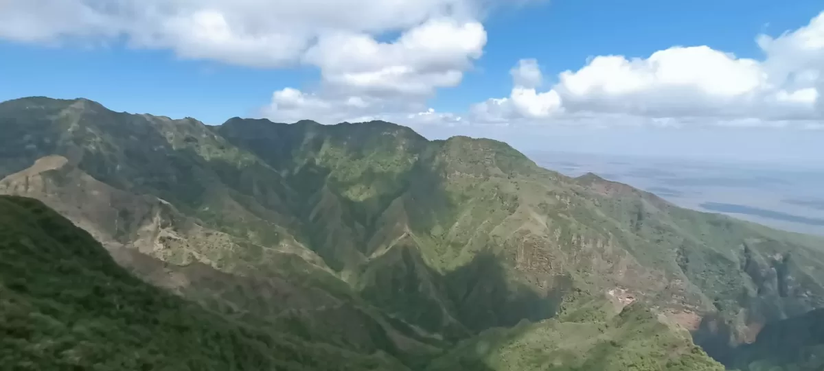
As Mount Kulal is of volcanic origin, lava fields define the landscape in the surrounding area. The mountain’s sides are steep and often slashed by deep canyons, especially on the eastern and western flanks. To the west, Lake Turkana lies at 410 m elevation. Meanwhile, the floor of the Chalbi Desert to the north is between 435 and 500 m. The highest point of Mount Kulal is 2, 335 m.
This peak is one of the remains of a volcanic crater located at the centre of the mountain ridge. But the eastern rim has been eroded over millennia to form the magnificent El Kajarta Gorge, which splits Kulal into two parts. The lower slopes give way to alluvial plains at 500 to 700 m. To the south, these plains are bounded by the even higher mountain ranges of the Ndoto and Nyiru (2 752 m).
Location
The location of a peak as high as Mount Kulal in the middle of one of the driest regions of East Africa not only makes it unique topographically but also contributes to the particular ecosystem services the mountain and its forests provide to the region. The climate of the region is driven by the northeast and southeast monsoon systems. The northeast monsoon provides hot, dry air masses that bring high winds from the north or northeast. A short rainy season occurs in October and November. To clarify, the southeast monsoon, originating in the Indian Ocean, hence more favourable for rainfall. The long rainy season is highly variable but usually peaks during April.
The topography of Mount Kulal creates what is known as orographic lifting: air masses are forced from lower to higher elevation, where they cool down and thus can no longer hold as much moisture as clouds and precipitation form. This phenomenon, along with the convergence of the conflicting monsoon systems, results in cooling and rainfall. Mist forests at the core zone of the MAB reserve aid in trapping moisture derived from the evapotranspiration occurring in the lowlands, and may increase local rainfall, although this has not been adequately studied.
Water source.
The Mount Kulal forests aid in holding water and delivering it to the villages on and around the mountain. Water is delivered by springs in the forest and on the shoulders of the mountain, as well as by seasonal and constant springs at the base of the mountain.
Up to a dozen springs and waterholes are known on the mountain alone. Intact forests at all levels, from the mist and cloud forests at the summit. This extends evidently to the villages of Gatab, Oltorop, Larashi, and Arabal and to the Acacia forests on the shoulders of the mountain. aid in the retention and absorption of the often short and intense rains and in preventing rapid runoff.
The rich volcanic soils that are increasingly used for agriculture to complement traditional herding practices are not the only important geological feature of Mount Kulal. The ancient lava flows filter and conduct water to springs throughout the region. Loyangalani Spring provides year-round freshwater on the eastern shore of the salty Lake Turkana. This has become the key to the largest settlement in the region.
Flora
Mount Kulal forest provides many resources to communities living on the mountain as well as those living at lower altitudes. The forest is the main source of building materials, firewood, and medicine for the local inhabitants. The deep gorges are used by morans, young Samburu warriors, as training and hiding grounds. Samburu villagers report the historical use of numerous caves, gorges and even cavernous fig-tree trunks as refuges during raids and prolonged battles with neighbouring pastoralists.
On a smaller scale, minerals are quite important to Samburu culture. Local people collect red ochre from Lorian lolkaria or “a place of red ochre” in the forest. The ochre is mixed with sheep-tail fat and smeared on the hair to make it beautiful and grow long. It is mainly used by moran, although young women may also use small amounts.